Were we ready for a great adventure to the west coast of Vancouver Island? Had we done enough time on the water to develop our skills to take on possible "big" conditions that are famous on the outside open waters? Were our camping skills ready to sustain ourselves for a long period of time and could our gear fit neatly into our Delta 15.5 Expeditions? We sure were going to find out as we embarked on a 9 night / 11 day trip between Brooks Peninsula and Fair Harbour with two other couples July 11th-21st.
Friday - July 11th
Our starting point would be at Fair Harbour some 500 km from home so Robyn and I decided to head to Miracle Beach Provincial Park south of Campbell River on Friday evening to shorten the drive the following day. As a kid my family used to stay at the Miracle Beach Resort that is no longer in operation so it brought back many happy memories to be camping in the park again.
 |
| Our first night of camping was not at a kayak destination. It was weird not having the RV with us. |
 |
| Looking north, Salmon Point on the left and Quadra Island beyond. |
Saturday - July 12th
After a lazy sleep in (6:00 am) we started the day with a healthy mushroom omelette with bacon on the side. Heading out in the kayaks the following day we figured we should get our last full breakfast as a treat since the next 11 days we planned to be starting our days with oatmeal or bannock with coffee.


 |
| Fair Harbour ... our starting point on this adventure. |
Arriving in Fair Harbour we located the Fair Harbour Store that looks after the marina and the old forest service campground down the road. There was lots of activity at the dock with fishing charters coming and going and lots of salmon being cleaned. The store is just a Britco trailer with a few essential supplies, fishing gear and even internet access for a fee of $10 or $5 if you like their Facebook page. It was tempting but we had decided that once we lost cell coverage just outside Campbell River we would stay off the grid for the duration of the trip.
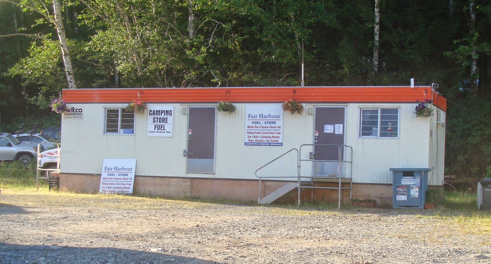
Our group of six decided to use only one camping site for our three tents so it was a great deal at $17.50 for the night since we would be heading out on the water taxi the next morning. Vehicle parking for the time we would be away came was $57.86 per vehicle which was very reasonable knowing that our ground transportation was secure. I had previously arranged the camping and parking space months in advance and it is highly recommended to make reservations if you are planning on using Fair Harbour as your starting point for a trip. Gwen and her staff were great to deal with and they can be reached through the contact information on the their website.
Just as we were checking in Gary and Jane Jacek arrived and not long after we picked a campsite Lynn Baier and Morley Eldridge arrived so our paddling team was complete.
 |
| The 2014 Bunsby expedition camp set up at the Fair Harbour Campground. |
 |
| Sitting around the fire after dinner contemplating the upcoming trip. Myself, Robyn, Gary, Jane, Morley and Lynn. |
On the way into Fair Harbour we thought we spotted bears in the river estuary so after dinner we went for a walk to have a look. Sure enough we spotted 3 of them about 1/4 mile away foraging in the marshlands. It was going to be a busy morning the next day so we climbed into our tents around 10:00 pm while it was still light outside and set the alarm clock.
 |
| An eagle that we spotted on a stroll around the estuary at Fair Harbour |
 |
| And our first bear(s) sighting ..... just close enough for us. |
 |
| Ready and eager to get going |
We're on vacation! What's with the 05:00 am alarm?? Time to get ready for Leo Jack and his Voyager Water Taxi service that would be picking us up at 8:00 am. Our gear needed to be doubled checked and ready for him as there was no coming back if anything was left behind. Everyone knows that "What did we forget" feeling when embarking on an adventure right?
As it turns out we were about an hour early in getting our gear down to the dock but it was better not to be rushed at the last minute and forget something. Robyn and I couldn't believe this was finally happening .... our first big trip and what a destination!
Right on time Leo arrived through the fog that had started to settle into the harbour. The loading process began and were soon on our way to our primary drop location at Jackobson Point on Brooks Peninsula.
 |
| We heard him coming before we saw him. Here comes Leo out of the fog. |
 |
| Loaded and ready to head out on a great adventure. |
Leaving the dock it wasn't long before we entered the fog that would be with us all the way to Jackobson Point. Leo has taken this route so may times I'm sure he could do it blind folded but he relied upon his Garmin navigation system to guide his way.
 |
| And into the fog we went. Very eerie but magical at the same time. |
Along the way to Jackobson Point we got our first glimpse of sea otters along the misty shoreline and even a humpback whale surfacing in the distance. What was behind the fog would have to wait until later in the day as it kept us in suspense the whole way to Jackobson Point. We arrived at our destination about 1 hr and 45 minutes later it was well worth the fare ($700 plus a tip) to get to our first base camp location.
With a low tide Leo had to drop us off in a couple feet of water so we quickly transferred our gear and kayaks to the beach. Leo had mentioned a couple of really nice sandy beaches that kayakers use just around the point but they are exposed to the swells coming in from the Pacific. There was one called Paradise Beach which we decided to head towards to see if we could safely land at and so the process began of loading our kayaks for the first time. It looked like everyone did their preparation work before leaving home. Nice!
 |
| Loading for the first time. Hey ... everything fit into the kayaks! |
The fog was just starting to burn off as we left Jackobson Point and headed toward Paradise Beach which is protected by some islets just off shore. Coming into the protected waters we got our first look at the beautiful sandy beach that would be our home for the next couple of days.
 |
| Just after high noon Robyn arrives at Paradise Beach |

 |
| Paradise Beach ..... all ours and free! |


 |
| One of the fishing floats that came ashore. The perfect anchor for my beer fridge. |
 |
| Pulleys and a lot of muscle means no food for bears! |
Monday - July 14th
We were all early to rise (6:00 am) and were greeted by a thick blanket of fog and not a breath of wind. Leo had mentioned that these conditions had been around for the past couple of days so our thoughts were that it would probably burn off around noon like the day before. We decided to head NW along the coastline in the fog with our GPS's towards the tip of Brooks Peninsula in hopes that it would burn off early and we would get to see the landscape. After a couple of hours navigating through some of the islets that were getting surge waves from the off shore swells we decided to head back to base camp. We were so close to the tip of Brooks Peninsula but the fog just didn't cooperate with us on this paddle to see it.
 |
| Into the fog we head out for an early morning paddle. |
Just as we were arriving back at camp the sun started to burn through the fog layer so we decided to explore the beach to the north of camp. Just around the point a couple hundred yards away I found babbling brook that was perfect for getting fresh drinking water as well as filling our portable shower that we brought with us. We thought it was hot the day we arrived but today was going to be even hotter. With no wind to cool us down we had the ocean to swim in and that wonderful shower! Awesomeness!
 |
| Exploring the rugged shoreline north of our camp. The fog was still hanging around the tree tops. |
I tried an interesting experiment with the float that I used for my beer fridge later in the day during the receding tide. I wanted to see if the float could escape from our little bay on its own? The rest of the evening I watched its progress and just before bed time I noticed that it was starting to head back towards the beach with the incoming tide. It was an amazing first full day out on the west coast with nothing but a great group of friends and nature to keep us company. Being off the grid never felt so good!
 |
| Sunset at Paradise Beach |
Tuesday - July 19th
One of the things I absolutely love about kayak camping is getting up before sunrise to witness nature waking up. It was just after 5:30 am when I crawled out our tent with my camera in hopes of seeing some of the nocturnal activities of the creatures around camp as well as the sun peaking over the mountains to the east.
Today would be moving day and the best news of all was that there was no fog. Typically the fog would start to form around 8:00 am so we decided that it would be best to be on the water by 7:30 am to make our first open water crossing towards the Cuttle Islets and the Bunsby Islands beyond.
 |
| Sunrise and moon set at Paradise Beach |
 During my early morning exploration of the shoreline I came across thousands of sand shrimp that were busy burrowing holes near the high water line. Nearly 1.5 inches in length, I was amazed how busy they were and that they were the creators of the holes in the sand that we saw during the daytime.
 Another nocturnal creature was also heading back towards the surf in the hundreds. Know as a shore crab (Hemigrapsus nudus) these little 2 inch crabs were heading back to the water after spending the night scavenging the sea weed at the high water line. Oddly enough I didn't see any crabs near the sand shrimp.
And there was my big float back on the beach almost exactly where I found it a few days earlier along with some new arrivals. I guess in a way Paradise Beach is a natural net that captures anything that enters its calm waters which explains all of the debris we found here. Out of all the beaches we visited on the trip Paradise Beach had greatest amount of debris which was sad to see.
 |
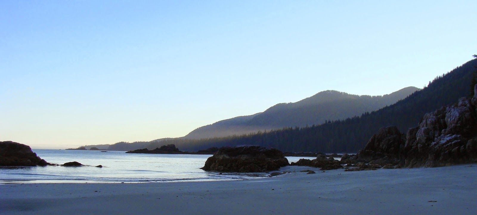
| Looking SE towards the Cuttle Islets. If there was going to be fog it would form in the distance and head our way. |
Right on schedule we were on the water by 7:30 am heading across Nasparti Inlet towards the Cuttle Islets. I was keeping a close eye on the horizon looking for any indication of fog forming but we were in luck as the fog didn't get a chance to form because the morning temperature was rising fast.
 |
| Leaving Paradise Beach heading towards the Cuttle Islets with Brooks Peninsula in the background. |
On any of the open water crossings that we would be doing there was a concern of the swells coming in from off shore and if the wind were to increase it would make the crossing let's just say .... interesting. But like the fog that didn't form, the wave height remained under 1 meter and the wind was barely noticeable.
 |
| Passing Yule Rock on our way into the Cuttle Islets it was perfect conditions to be moving base camp to the Bunsby Islands. |
One of our paddling partners is a professional archaeologist (Morley) and he was very interested in many of the islands that we visited on the trip. On this particular paddle Morley located a burial sea cave and saw the resting place of a couple of First Nations people. With respect to site no photographs were taken nor were any artifacts touched and Morley was the only person to witness the site.
 |
| Entering the Cuttle Islets, Morley was busy with his GPS identifying potential sites of interest. |
The Cuttle Islets were an alternate starting point of our adventure had the sea conditions been too big for Leo to take us to Jackobson Point. There are many islets to explore in this tiny group and we would like to visit them again and spend a few days here on another trip.
 |
| The primary camping location in the Cuttle Islets. We must come back here again. |
 |
| The view looking west to Brooks Peninsula from one of the Cuttle Islets that is used as a kayak camping location. |
While on a rest stop we explored the islet a bit and the girls found a dead sea otter that had washed up in the tiny bay at low tide. It was a stark reminder that the cycle of life occurs even in such a beautiful setting.
 |
| Robyn and Jane examine a dead sea otter on the beach. Our destination of the Bunsby Islands are in the distance. |
After leaving the Cuttle Islets we decided to head to Battle Bay just around Accous Peninsula to top up our water supply. We spotted Leo heading towards Brooks Peninsula with a couple of kayakers and in fact we spotted him a few times on our trip making runs up and down the coast. Other than Leo we really didn't see or hear any other boats while on the trip other than our visit to Kyuquot a few days later.
On the way Morley located a possible fish trap that was just up a river close to Battle Bay. He did manage to paddle a bit up stream and find what could have been the foundation of the trap and possible grounds where buildings might have been. While Morley was busy with his site, Gary and Jane went looking for a known downed totem further towards Battle Bay. However with the passing of time the land continues to reclaim artifacts that have been left behind by the First Nations peoples. It is unfortunate that we were unable to locate the totem as the forest and undergrowth have eliminated any indication as to where the giant may be resting.
 |
| Upstream Morley surveys the river banks for archaeological possibilities while Lynn watches from the gravel bar. |
 |
| Stopping at the river on the way to Battle Bay |
After finding the water source in Battle Bay we started the last crossing of Ououkinsh Inlet on our way to the Bunsby Islands. From a distance it is hard to tell that there are a couple of passages running between the Bunsby Islands but that is where having a chart available to navigate making it relatively easy to find.
 |
| Finding the passage at the Bunsby Islands we began looking for a place to make base camp. |
Our goal was to locate the campsite on the outside island known as Cautious Point but when we arrived we noticed a number of tents already established at the site. Looking at a few other options close by Robyn located a little islet that we called Middle Islet because it is between the (IR) Checkaklis Island and Cautious Point. It was absolutely perfect with a white shell and sand beach that was protected from the open water swells and wind. There was a small kitchen area already established and a grassy ridge that was the perfect place to put our tents.
It was just reaching noon when we landed and started to set up our camp but first it was time to take a dip to cool down. Today would be the hottest day so far that we experienced and it wasn't long before a tarp was set up over the kitchen area to provide a little shade.
 |
| Morley and Lynn commented that the conditions were almost like Mexico. Hot, great beach and amazing views. |
The panoramic 360 degree views were spectacular. From our tent, the front vestibule had the view of the beach while the rear vestibule had a view of the Bunsby Islands. Does it get any better than this?
 |
| Looking the opposite direction from the grassy ridge. Enough room for at least 6 tents at this location. |
The beach above the high water line had plenty of space to leave our kayaks on the driftwood while a huge log acted like a breakwater when the tide came in. Because we were on a small islet our food would be kept in the kayaks overnight since the risk of bears or wolves coming to visit us was very low. We spent the rest of the day just lounging around absorbing what nature was giving us.
 |
| Kayaks unloaded and the tarp set up to get relief from the sun. |

 |
| The kitchen area also served as Gary's planning session for tomorrow's day paddle around the Bunsby Islands. |
The tide goes out a far way on these little islets as you can see below compared to our arrival picture. It also allowed us to walk around the the waterline and explore the inter-tidal zone. The beach on Cautious Point island across from us is where a group of about 8 paddlers came back to later in the day and we figured that they must be part of a kayak tour that frequents the area.
 |
| The end of another great day as everyone chips in with the dishes after dinner. |
The track of our adventure so far. The grey track is Leo's water taxi from Fair Harbour to Jackobson Point 28 nm away.

Tomorrow would be another great adventure as we circumnavigated around the Bunsby Island group but you'll have to check back in a few days for part 2 of the Bunsby 2014 trip. Thanks for stopping by to read the blog. If you have any comments please feel free to share them with us.
No comments:
Post a Comment