Sunday, August 26, 2012

Stairway To Nowhere

Changing our kayaking plans from camping this weekend until next weekend we decided to head out for a day of exploring Saanich Inlet. For the benefit of our readers who may not know where this is, it is located between the Saanich Peninsula on the east and the Malahat on the west on south Vancouver Island. The inlet is about 24 km long with a maximum deapth of 225 m (738 ft.) and extends south from Satellite Channel at Saltspring Island through Squally Reach and down to Finlayson Arm in the south. Goldstream River (BC Provincial Park) feeds into the inlet and is home to a major Chum salmon run in the fall months.

Our put in location was next to the Brentwood Bay BC Ferry Terminal that operates between Brentwood Bay and Mill Bay. The small beach suits us just fine for our Brentwood Bay launches but it is recommended to have a set of kayak wheels to roll your fully loaded rides down to the water. The municipality has done a wonderful job in providing a cement walkway (although steep) to the water and recently installed washrooms next to the unloading area. Parking can be a bit of an issue and it is not uncommon to park a good distance away up the main drag unless you have connections (local parking lot attendants / friends houses) LOL or arrive early in the morning to get parking close by.

Robyn on a perfect day launch next to the BC Ferry Terminal. 

On plan today was to make our way to Spectacle Falls on the western side on the inlet and in particular visit a site known as Stairway To Nowhere. We were on the water at 09:00 and with mirror like water we headed across the inlet to check out the decommissioned Bamberton cement works. Established in 1921 the cement works operated as the BC Cement Company was a major source of cement on southern Vancouver Island until it was closed in 1980.

Moon Jellyfish
On the 3 km crossing from Willis Point over to Bamberton we noticed a large number of Moon Jellyfish. We had seen these jellyfish in the early spring but the largest ones were no more than a couple of inches in diameter. Today the largest ones were around 9 inches in diameter and there seemed to be a lot more than in the spring.


Lion's Mane Jellyfish
Our real find was the giant Lion's Mane Jellyfish that Robyn spotted just under the surface about a kilometre from Bamberton. The "hood or bell" of the jellyfish was about 2 feet in diameter and the tentacles extended for several meters flowing in the ocean currents. On our track you can see where we stopped and got to work with our Fujifilm XP50 waterproof cameras. With the early morning sun and calm water it was the perfect conditions to take some underwater pictures and videos.  


No much left of BC Cement Company
After our jellyfish adventure we made our way  to the Bamberton cement works and checked out how much is left of the plant. Other than a couple of fuel and water tanks there isn't much left of this facility that I remembered from my youth. This morning a couple of workers were busy with cranes hoisting parts onto barges for disposal.

Our next goal was to make our way down to Squally Reach and then find the Stairway To Nowhere. This landmark was created for a movie 'Commandos Strike at Dawn' filmed in 1942 and was left as is. When coming around Squally Point we saw the stairway and it is kinda weird seeing it for the first time.


Stairway To Nowhere
One of the reasons that we wanted to reach the stairway was to locate a Geocache that is located there. However as we were looking for a place to land our kayaks the winds from the north picked up dramatically with white caps starting to form. It was decision time and we could see that the eastern side of the inlet was calmer so we high tailed it out of there and sloshed our way across the inlet to the sheltered waters of McKenzie Bight. Murphy's Law ..... once reaching the other side the winds dropped and the water flattened out so ........ back across we went to the stairway!  LOL


Robyn on the stairs
We found the Geocache that hadn't been found since October of 2011 and had a great lunch stop on the small beach just around the corner. It was time to head back across the inlet for the third time to fully explore McKenzie Bight and although there wasn't really any wind what there was was being forced through Squally Reach. It really showed us how the wind and the landscape can work together to create crazy water conditions. I wonder what Squally Reach really looks like on a bad weather day???


Seal colony on a beach nook
We had been to McKenzie Bight before when we hiked down to the beach so this was neat to paddle in and see the hikers / tourists taking our picture as we played in the rock gardens. One thing that I forgot to mention was the great number of seals that we saw on both sides of the inlet. They seemed to be our escort for the whole day as we never were really alone exploring all the nooks and crannies of the shoreline. Several times we came across seal colonies in some of the small crevices and so many curious baby seals were checking us out.


Feeling pretty good with our paddling today we decided to check out Tod Inlet on the way back to our put in location. It was just around 3:00pm when we made our way past Butchart Gardens dingy dock and holy cow ......  the number of mega yachts, sailboats and about 2 dozen rental kayaks all trying to maneuver in such a small area. The big attraction was the Saturday night Butchart Gardens fireworks show and the boaters were all jostling for anchorage. The only thing I could think of was how the heck were they going to get out of there in the dark???? Maybe some of them would be smart and wait for daylight before trying to leave the inlet. 

A few rental kayaks and only about a 10th of the total "money boats" at anchor.

Leaving Tod Inlet we checked out the Brentwood Bay marina and played "duck" under the dock gangways as the tide was coming in. Good forward fold yoga practice beats banging your head or catching a paddle.  LOL

We arrived back at our put in location at 3:45pm (6.75 hours) and with a total of 26.70 km travelled making it our longest paddle to date. Good practice for next year when we look to head to the west coast on a multi-day trip.


Monday, August 20, 2012

Portland Island Camping

After visiting some of the many wonderful kayak camping destinations on our recent vacation we went to work planning our first solo camping trip which took place this weekend. Our goal is to gradually build up our touring / camping skills by kayak so that one day (maybe next year) we can head out on an extended trip.

Our first kayak camping experience was this past April when we attended the West Coast Paddler Campout to Portland Island and we selected this location again as it is only a couple hours from home. It was also a great opportunity to try out some of the new gadgets that we have acquired over the past couple of months.

I did the pre trip planning in regards to the weather and tide forecasts while Robyn handled the culinary menus for the weekend. With the recent heat wave that hit the west coast it was a perfect opportunity to camp in a tent rather than our normal RV mode. We launched out of Ardwell Beach at 3:30 Friday afternoon under sunny skies with almost no wind and headed towards Portland Island riding the flood tide along the way. The flood current through John Passage was fun to play in and it carried us to the end of Coal Island where we stopped to check out the BC Ferry traffic. With only the 4:00pm Spirit class still loading at the berth we crossed Colburne Passage over to Pym Island.


Coastal class on the left heading to Tsawwassen and Spirit class on right heading to Swartz Bay behind Hood Island

The Shute Passage crossing was relaxing as we rode a gentle flood tide towards Brackman Island and then to Shell Beach to check out a number of kayakers unloading and setting up camp for the weekend. Our destination was Arbutus Point on the northern end of Portland Island and a couple of the kayakers said that they saw nobody there a few hours earlier when they passed by. Making our way along the west side of the island we arrived at Arbutus Point and to our amazement there wasn't a soul in sight. We had the whole camping area to put up our new 3 person tent and call it home for the weekend. In fact we only saw a few people all weekend who hiked over from Princess Bay so we named ourselves "Arbutus Camp Hosts" for the weekend. LOL

Sunset over Saltspring Island
We choose probably the best camp spot to watch the sunset but in reality it probably was the noisiest spot as well because of the waves from the ferries crashing into the base of the rock ledge that we were perched on. Once the ferries stopped running close to midnight the waters calmed down and we fell asleep listening to the seals splashing in the water below us until a couple of raccoons climbed the tree above our tent at 2:00am. Camping in the wilderness ........ priceless!!  :-)  One thing we noticed and I have to ask other kayak campers about, is even though there was no moon (new moon), the inside of our tent was surprisingly lit inside. Robyn thought that my watch LED was on but it wasn't so all we could figure out is that the star light somehow was captured by the fly material creating a artificial light source for inside the tent.


The 8:00am ghostly departure from Swartz Bay
Sleeping in until 8:00am on Saturday morning we woke up to the numerous Oyster Catchers squawking on the rocky point of the campground. It was time to start what would be a very relaxing kick up our feet type of day that we envisioned. For breakfast we made cinnamon raisin bannock for the first time and it was simply amazing with a hot cup of Silk Road tea. I think we have found a new camping treat that can be made with almost anything you can image and so easy to do as well.


Our two 2:00am visitors the next morning below our tent. How cute are they????

Watching the tide go out from our camp I spotted what I thought was a river otter crawling up onto the exposed flat rocks of the point but then we realized that it was a baby seal getting a little morning sun. I headed down to the point and sure enough it was a baby seal and it had no problem in letting me get within about 10 feet as I was concerned that it might be injured since it's mother was nowhere in sight. The little guy (which we named Neil the Seal) looked strong and like I mentioned just wanted to catch some rays. He spent a good 4 hours soaking up the warmth before leaving the beach unannounced.  :-(

At low tide we scavenged the tide pools looking for a possible dinner candidate (crab) but none were to be found. However we did manage to find a few oysters and decided that a few of them would be nice for lunch steamed in white wine and butter and topped with parmesan cheese. The rest of the afternoon we spent reading and just plain doing nothing just as we had planned to do all along.

Keeping an ear and eye out for the Sunday morning forecast I checked my iPhone and VHF radio for updates. The Sunday forecast had gone from winds light to now increasing 10-15 knots from the south so we put a plan in place to wake up the next morning and reassess the weather conditions. Worst case scenario we would just simply relocate down to Shell Beach and wait out any bad stuff. After another great meal of curried chicken and rice for dinner the wind started to come up and with over cast skies we retreated to our tent and read until we were ready to doze off. As I waited for the last ferry to pass by our rock ledge I watched the lightening flashes in the distance light up the tent and only heard the odd thunder roll. A great way to finish the day off but I would have liked to see the lightening a little closer in all its fury.  :-)

Sunrise looking over our private beach for the weekend. A great way to wake up in the morning!!

Sunday morning we woke up before sunrise and climbed out of the tent to see the sun coming up over the Salish Sea. It was a pretty amazing sight that we never get tired of no matter how many times we see it. Over a fresh brew of Silk Road tea and bannock I checked the weather forecast and sure enough it wasn't looking good for later in the day with predicted 25 knot winds from the south. It was time to pack up the kayaks and "Get out of Dodge" as we launched from our beach front property ($4.90 per person , per night) at 8:05am and headed south towards Shell Beach. With an ebb tide that would follow us home we rounded Kanaka Bluff and saw that Shute Passage was absolutely flat. As we passed Shell Beach, kayakers were busy loading their rides obviously aware of the forecast as well.

The ebb flow was pretty obvious in Shute Passage and especially with the big rollers coming off Celia Reefs, we ferried our way to Pym Island to hold our course. We crossed back over Colburne Passage and headed south through Iroquois Passage letting the currents carrying us back towards our put in location. After a few hugs and high fives we loaded the truck as we watched the south winds starting to build in the bay. Shortly after 10:30am we walked through the door at home feeling pretty good about our solo camping experience and have already begun to plan our next tenting adventure.


Monday, August 13, 2012

Flat Top Islands - Day Five (Revised)

WOW!!  What a whirlwind finish to our vacation. One day we are paddling out to the Flat Top Islands and the next day we are at Victoria's Largest Little Airshow raising money for great charities.

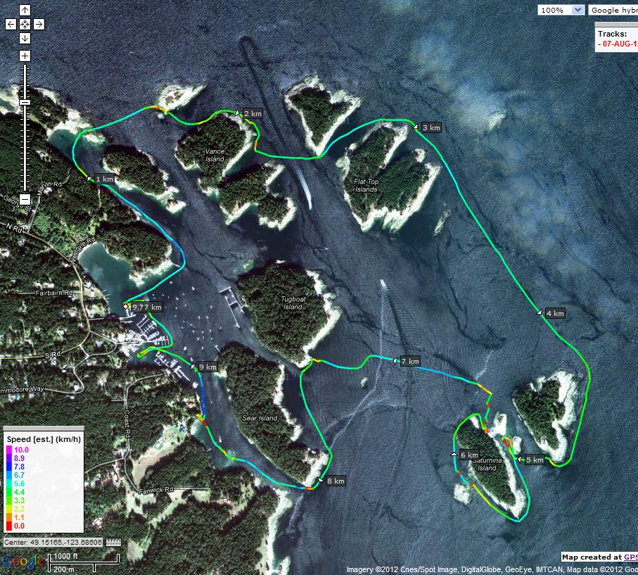
So here we go .......  For our Day Five paddle we planned to head out to the Flat Top Islands located at the south east end of Gabriola Island and visit one of the most beautiful kayaking locations that we could only dream of. Our kayak Sensei recently posted pictures of this magical place and we just had to see it for ourselves. 

Photo courteous of Sheila Rami-BamBam Porteous


Silva Bay Kayak Adventures
We left our base camp and headed to the Nanaimo BC Ferry dock servicing Gabriola Island for the 09:30 departure for just a small "hop" across the Northumberland Channel. Pre-planning (thanks Wendy) really came to to pay off big time as our put in location at Silva Bay has limited access points so we contacted Silva Bay Kayak Adventures to see about launching from their location. Pat Masson was was absolutely fabulous in allowing us to have access to their facilities for the day so we just rolled our rides down to their dock and we were on our way to visit the Flat Tops.

Leaving the Silva Bay we found many islets that were home to seals and in particular on this day the number of baby seals was quite amazing. Like curious children they seemed to wonder what we were doing and came closer and closer to us until their mothers chased them away.


The first things that we realized that there are so many islands in the Flat Tops that it would be really easy to get "lost" if you didn't have a map or GPS (we had both) to find your way back to the launch location. However, having knowledge where we were, we started our clockwise trek to see a little bit of them all while keeping our goal of visiting that little piece of heaven on water in our minds.

Meandering our way through the islands we headed out to the northern side of Acorn Island and here we got our first view of the Straight of Georgia with nothing between us and the British Columbia mainland. It was amazing how small we felt and it almost had a weird feeling of being alone as we couldn't see land anywhere except behind us.

Bath Island on the left, Saturnina on the right and the special spot in the middle

Making our only crossing of the day we headed towards Bath Island and in the distance a got a glimpse of our goal that we came for. We decided to round Bath Island and come at the Crown Flat Top Islets from the south so that we could enjoy every angle of their beauty. Our first view was simply amazing and we were very proud that we accomplished this kayaking "bucket list" item. 

We then paddled around Saturnina Island and came at the "Crowns" from the north and decided to land for lunch on the gravel bar connecting the islands at low tide. 

Here we came across Ryan and Malory Masson who were guiding a youth group having lunch on the same beach. We also met the couple from our previous trip to Pirate's Cove so we shared some more laughs and stories with them before they headed off. Today the main camping area on the islet was occupied so we didn't intrude but we did explore the exposed sandstone formations that the islet sits on. 


The landing shelf with the camp just above.
Looking back towards Saturnina

All things must come to an end so we sadly left our lunch beach and hope to return one day to spend a night or two on the Crowns. Now that would be magical!! 

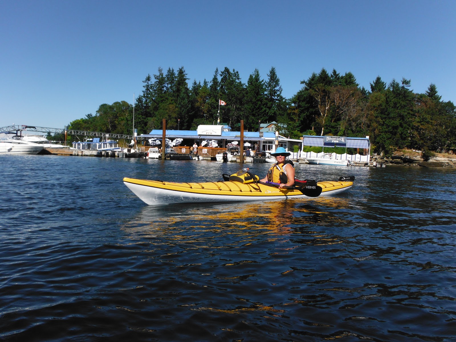
We headed back towards Silva Bay exploring the other marina and resorts and stopped by the Silva Bay Shipyard School which is home to Canada's only full time wooden boat building school. 


Arriving back at our put in location we loaded up the kayaks and headed towards the other end of Gabriola Island to check out the Malaspina Galleries and another special place along the way. Robyn's parents owned this cabin (center section) in the early 70's and since then a number additions to the main cabin have been made. It was nice to see it still standing and now someone else pride and joy.


Making the 16:30 ferry back to Nanaimo we reached base camp at Living Forest Campground just in time to experience the lightening storm that hit southern Vancouver Island. It was a pretty good light show and capped off a great last day on the water in the Nanaimo area. We can't wait to go back!! 


Saturday, August 11, 2012

Flat Top Islands - Day Five

A quick update .... first I still have to complete the Flat Top Islands blog but currently we are are at
Victoria's Largest Little Airshow where we raised over $15,000 for our two charities on day one!!! We expect to raise another $10,000 on Sunday which will bring our total raised over 11 years to $170,00.00!!!

I'll update the blog in a couple of days regarding the Flat Tops and the airshow.

Mark

Tuesday, August 7, 2012

Pirate's Cove - Day Four

Monday morning we woke up to slightly overcast skies and a change in the wind direction for our paddle over to Pirate's Cove in the De Courcy Group of islands. One thing that we have learned from paddling in North Gulf Islands is that they provide a certain amount of shelter from the winds. The wind forecast was calling for SE 10-15 increasing to 15-20 later in the day so we headed to our put in location at Cedar By The Sea that we scouted out the day before. Arriving at the beach we only had a slight breeze to contend with coming from the SE.  

Round Island with Link Island in the background to the right.
Our plan was to paddle over to Round Island, check the water conditions at that point then make the crossing over to Link Island. Yesterday while scouting out the trip we had seen small boats coming from between Link and De Courcy so we knew we might have a few options after the crossing was completed. The crossing went as planned and we didn't notice any ebb current coming from Dodd Narrows which I was expecting so that was a pleasant surprise. 


Arriving at gap between Mudge Island and Link Island we checked to see if there was any passage through but it became clear that this pass had become blocked many years ago with a gravel bar as indicated on the charts. We proceeded south along the west side of the Link Island and here we got to see our first massive galleries of sandstone erosion on the cliff faces. Some of the cave like hollows are so massive in scale that we could paddle under the overhangs but we kept our distance as the sandstone formations are in a continuous state or erosion.


Paddling further along the cliffs we came to the pass between Link and De Courcy Islands where we saw boats coming through the day before. Probably only used by small powered boats and of course us kayakers the gap is just that... a gap between the sandstone rocks. A small amount of current was present here but the weird thing was that we could actually stay in position between the rocks with the river like flowing under us. Why??? Another thing I need to research.  LOL


Down the east side of De Courcy we navigated through the many small islets on our way to Pirate's Cove. There are many small cottages on this side of the island and each owner have their unique way of making it theirs. Probably one of the coolest things we saw was this hot tub that was a summer project just recently completed. It can be run on propane during the dry summer months or wood during the winter months. Robyn stopped to speak to the owner who saw us and he said that they also add lavender to the the heating chamber to create an amazing aroma. Nice!!  


Arriving at Pirate's Cove Marine Park we explored the protected harbour before we headed around to our lunch stop location on the Ruxton Passage side. Here we met a couple in a tandem kayak who were from Seattle. They had come from Silva Bay through Gabriola Passage so it was good to talk to them about launching locations for our next planned trip into the Flat Top Islands. 


Lunch stop at Pirate's Cove (Ruxton Passage side). One of our future camping locations.


For most of the day it was overcast and although there wasn't much wind there was a noticeable SE swell present now at the southern end of De Courcy. We decided to head back up the west side of the island towards our put in location and even though the water was a bit sloppy at least we were going with it. Some of the sandstone formations were alien like along the way. As we got closer to the pass between Link and De Courcy Islands the swells dropped a bit so we made a direct crossing back to Cedar By The Sea. Another great day visiting a kayaking bucket list destination. :-)


Sunday, August 5, 2012

Rest Day - Day Three - Paddle #50

After the day two paddle to Nanaimo we decided to take a day off and hike in to see Dodd Narrows at its full ebb on Sunday morning. Along the way we did a little Geocaching but once we reached the narrows viewpoint we hung around and watched the blingy yachts and other boats battle the currents. The first yacht that came through almost lost its dingy and then we watched a little tug "grunt" its way through the narrows. Pretty cool! 


We then headed to Cedar On The Sea to find the put in location for making a trip over to De Courcy Groups of islands on Monday. The boat launch was extremely busy with small powered pleasure craft and kayakers coming and going. We figured it probably wouldn't be a busy on Monday but we'll have to wait and see.

Heading back to base camp I whipped up a batch of sushi then we suited up for an evening paddle in the river as the tide was coming in. Yeah we know ... it was supposed to be a rest day but what the heck we thought it would be best to get paddle #50 out of the way. Anyway it was a great opportunity to try a few rolls (that didn't work) and then I tried my hand at kayak paddle boarding. That didn't work either!  LOL

Tomorrow we head to Pirate's Cove.

Nanaimo By The Sea - Day Two


I normally put our track at the bottom of the blog entry but yesterday's track covers so much distance in the Nanaimo Harbour area that I think it would be better to show it first so that you get a better overview of our paddle.  


Yeah ... our longest (distance 21.95km and time 7.5 hours) paddle to date and #49 on our kayaking adventure. Amazing huh???

We left the river access at Living Forest Campground at 10:25am knowing that we had to get out of the estuary fast with the ebbing tide. Lucky for us we only has to walk our rides about 20 feet in one of the river channels and then we were on our way towards the Nanaimo harbour for a fun day of exploration. 

The predicted NW winds were blowing 10-15 knots into our face so we hugged the coastline until we had to transit around the Nanaimo Port Authority and then it became a bit of a slog until we reached the the Nanaimo Water Airport home to Harbour Air. One of the first things that we noticed was how busy the waterways are here with pleasure craft of all types and then throw in seaplanes trying to take off and land. Although on charts the sea plane activity area is marked there seemed to be no firm rules that pleasure craft are not to use those areas.


From this point on we were sheltered from the winds by Newcastle Island as we paddled through the various boat jetties and up the narrow channel that separates Nanaimo from Newcastle. Newcastle Island is a marine park and prior to this trip we really had no idea that it was such an amazing place and a very popular destination for boaters and kayakers. There is small walk on ferry service from the Nanaimo harbour so there are lots of ways to get there. Making our crossing over to Newcastle we made a quick stop to find a Geocache before heading towards Departure Bay.

Stopping for lunch we had a great view of Departure Bay and the BC Ferry service that goes between Nanaimo and Vancouver. There were a number of other kayakers also stopped here as well as a local scuba diving boat anchored just off shore. Once again we had no idea that Newcastle Island was such destination play area.


The seascape of the northern Gulf Islands is so much different than the southern island close to home. Everywhere we see what looks like volcanic rock that was once filled with air bubbles but I think that they might have been rocks that have worked themselves loose over time. I guess I need to research this a bit to figure out how the islands were formed.


An armada of kayaks heading towards us
After our lunch stop we paddled south towards the Dingy Dock Pub and as we came around Bate Point into Mark Bay :-) the number of pleasure craft at anchor really came into view. In between all of the boats we saw what must have been at least 50 kayaks heading towards us. At first I thought they must have been some sort of tour group but then we figured out that it must have been the Nanaimo Paddlers out on a day paddle to the islands.


Newcastle Island dock access


Playing a bit in the shallow waters between Newcastle and Protection Islands we headed to the famous Dingy Dock Pub for refreshments. They even have kayak and dingy docks to tie up at which is pretty cool!! The beer, margarita and food was great and what the heck .... we bought a Dingy Dock Pub t-shirt as well!!


The Dingy Dock Pub ..... like they say on the Food Channel.  "You Gotta Eat Here!"


Time to head back towards our base camp at Living Forest so we kept a close eye out for marine traffic and sea planes before crossing back over to the Nanaimo Water Airport. The good thing is that you can see approaching sea planes and those taxing out for take off.

The NW winds had pretty well dropped off by the time we headed into the Nanaimo River Estuary and with the flood tide, the paddle back was pretty easy. Good thing as we were starting to feel the effects of 34 C heat, length of paddle and the time on the water today. Arriving back at the river put in location there were lots of kids playing in the warm water and it looked like the kayak rentals doing a great business today as well. Hummm ...... maybe a good place to practice tomorrow on our rest day. :-)

Saturday, August 4, 2012

Ladysmith Harbour

Day one of our paddling vacation and our base camp for the next 5 days is Living Forest Campground in Nanaimo. From here we plan to do day trips to various locations depending on the wind conditions as some of the destinations will involve open water crossings.


Yesterday we chose to explore Ladysmith Harbour that we have seen so many times while driving the island highway. Our put in location was at Transfer Beach that is home to Sealegs Kayaking and boy were they busy today renting out their fleet of Delta kayaks. 

Heading north from the beach we paddled past the saw mills that were busy processing logs from the booms tied up in the harbour. Back in the logging boom (pun) days the harbour was full of logs waiting for processing but today the storage booms are mostly empty.


Working our way over to the east side of the harbour we navigated through the many islands and islets. Another first for us was a seal playing close by doing full out of the water breaches and this is where you need a really good high speed camera or a GoPro which was in my back hatch (LOL). I did manage to get  picture of the seal's last entry splash and he was not to be seen again.

We did come across a unique marker which we have only seen from the land position in the past so it was kinda neat to see this one. Travelling with our GPS it has a special meaning for us as we now were at the 49'00.00 N Parallel of Latitude. We use our GPS not only for navigation on the water but also when Geocaching. There is a Geocache listing for this location but Robyn went ashore and couldn't locate it and by the previous logs it looks to be gone. Too bad as it would have just made the discovery of the marker even more special.


In the sheltered waters between Dunsmuir Island and Hunter Point we found the remains of a sail boat. This is not the first time that we have seen the sad endings of someone's pride and joy below the water. 


We had launched at near low tide which presented many different seascapes on the way to our lunch stop especially the visible connections between the islets. On our way back the sail boat was completely under the water and we were able to paddle through the gap in the picture below.

No pass through here on the way to our lunch stop but we came through on the way back with about 6 feet of water.

Making our way through Sibbell Bay we rounded Sharpe Point and headed into Evening Cove towards our planned lunch stop location of Elliot's Beach. We have been to this beach before to Geocache but not by kayak so today it was great to paddle in and relax in the warm sun while having a late lunch.


After our rest stop we ventured out to Coffin Point to get a better view of Thetis and Kuper Islands which is another one of our kayaking bucket list destinations. The predicted NW 10 - 15 knot winds had almost totally disappeared and the water was starting to become like glass. We played around Coffin Island a bit in the small rip currents then started our trek back towards Ladysmith with the flood pushing us along at a pretty good pace. A perfect way to start our paddling holiday!!